LOCATIONS
N – Q
A – B C – E F – I J – M N – Q R – T U - Z
|
PLACENAME |
WHERE |
HISTORY |
|
Narrowdale |
32 miles from Dunedin, near Milburn on southern railway line |
|
|
Newhaven |
Small settlement near Pounawea at the mouth of the Catlins River |
|
|
Nugget Point
|
Prominent point of coastline beyond Kaka Point |
Also known as ‘Tokata Point’. Lighthouse on Nugget Point first lit 1869 |
|
Nuggets, The |
About 20 rocks off Nugget Point. |
Named this by whalers. Maori had name for every one |
|
Ohiti/Ohito |
Catlins Head |
Means ‘cautious, be on one’s guard’ |
|
Omaru |
Mount Omaru is one of two prominent hills between Romahapa and Glenomaru. Also Omaru Stream and Little Omaru Stream, tributaries of Glenomaru Stream |
Named after a Maori chief
|
|
Opito |
The Blowholes |
Means ‘the navel’ |
|
Otanomomo |
Old railway siding on Catlins River Line, beyond Finegand. Former school of that name on Settlement Road, Paretai which changed its name to Paretai after 1960. |
Otanomomo estate established by TELFORD. In 1858 Thomas REDPATH established the first store south of Dunedin on the Puerua River. |
|
Otaraia |
Hill that was landmark on old track between Popotunoa and Tuturau. |
Named after Taraia |
|
Otekura |
District inland from Sandy Bay, about 5miles from Port Molyneux and further towards coast from Glenomaru and Ahuriri |
Means place of red feather |
|
Otiwha |
Little creek near store at Kaka Point |
‘Tiwha’ is patch of shell or wood put on a hole in a kelp bag |
|
Owaka |
Town centre of Catlins District, 37km from Balclutha. |
Early variant of name ‘Owaki’ ‘Owake’ ‘Owarker’. Name means ‘place of the canoe. |
|
Owaka Harbour |
Known in early days as Catlins River |
Sometimes known as Newhaven Harbour |
|
Owaka River |
Rises on nthn side of Wisp Range, flows down Owaka Valley to sea |
|
|
Paiwata |
Tributary of Kaihiku. |
Spelt by early settlers as ‘Pie-water. Meaning is ‘fence of storehouse’ |
|
Papatowai |
Settlement near mouth of Tahakopa River, south side, 3km from Maclennan |
‘Papa’ is flat, ‘Towai’ is native tree also known as Kamahai |
|
Papatupu |
Old railway station and post office (1913-1916) closed in favour of Tawanui |
|
|
Parae |
Old railway station of Tahora on north bank of Owaka was renamed Parae to avoid confusion with Tahora in North Island |
|
|
Paretai |
Lies between the Puerua River and Koau branch of Clutha River, 16km from Balclutha. |
Originally part of Telford estate. Paretai means ‘bank of a river’ |
|
Penguin Bay |
Bay near the ‘Blowhole’, south of Jack’s Bay, north of White Head |
|
|
Pillan’s Head |
Headland 2 miles west of Long Point |
Named after WS PILLANS, nephew of FS PILLANS, early runholder |
|
Pillan’s Stream |
Small creek running into sea east of Pillan’s Head |
Maori name ‘Hiri koura’, the saltwater crayfish is ‘koura’ |
|
Pohaaroa |
Peak in Kaihiku Range behind Warepa Bush |
Name means ‘full love’ |
|
Pollock’s Hill |
Hill on west side of old railway line between Glenomaru and Hunts Road |
Named after sawmiller |
|
Pomahaka Downs |
Estate in Popotunoa district |
|
|
Pomahaka River |
Large tributary of Clutha River, rising in Umbrella Mountains and Mount Benger, flows along western side of Blue Mountains |
Correct spelling ‘Pou-mahaka’ meaning posts (driven into banks) to snare ducks |
|
Popotunoa Popotunoa Hill |
District near Clinton, originally referring to wooded hill. |
Name probably refers to boundary between Ngai Tahu and Ngati Mamoe tribes, marked by post in ground. Post ‘poupou’, ‘tu’ standing, ‘noa’ common to all |
|
Port Molyneux |
Old township at mouth of Clutha River and entry port for South Otago, 19km from Balclutha. Township now gone |
After big flood of 1878, the river made two new mouths further north and the original mouth silted up. |
|
Pounawea |
Township on estuary where Catlins Lake and Owaka River join, 5km from Owaka |
Maori name for Catlins Lake. Name means ‘post set on fire’ |
|
Puaho |
Road running from Maclennan across hill to Purakauiti |
Name presumed to be in reference to Ngati Awa chief, Puoho |
|
Puerua |
District about 3 miles north-east of Romahapa. Puerua Stream runs into Clutha River near mouth |
Name means ‘two posts’ |
|
Pukekoma |
District about 29km from Balclutha, north of Hillend |
‘Puke’ means hill, ‘koma’ type of stone |
|
Pukepito |
About 8 miles up river from Balclutha |
BEGG’S station was at Pukepito. Name means hill end |
|
Pukerau |
Small township between Waipahi and Gore. |
Names means ‘leaf hill’ |
|
Puketi |
Small district between Greenfield and Waitahuna West |
‘Ti’ is cabbage tree ‘Puke’ is hill |
|
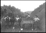
Puketiro
Road Builders at Puketiro |
Mountain and old railway station between Owaka and Tahakopa, 21km from Owaka |
Name means hill with view |
|
|
|
|
|
Purakauiti |
Tributary of Purakaunui River |
The little Purakau |
|
Purakaunui |
Name of small river flowing into Purakaunui Bay, between Catlins River and Long Point. |
Famous Purakaunui Falls on the river |
|
Purekireki |
District at head of Owaka Valley, 26km NW of Owaka |
Name means ‘a heap of flax’ |
|
Purple Hill |
Small hill on right hand side of road about 7-800 metres along Back Road, Port Molyneux |
Origin of name unknown (can you help?) |
|
Quakerfield |
Now part of Owaka |
Name of block of land cut up in 1895 |
A – B C – E F – I J – M N – Q R – T U - Z
|
Sources: |
‘Pioneering in South Otago’ by F Waite, pub. 1948 ‘Catlins Pioneering’ by AR Tyrell, pub. 1989 ‘Faith and Toil’ by DJ Sumpter and JJ Lewis, pub 1949 ‘Full Circle’ 1975 ‘Place Names of New Zealand’ by AW Reed, pub 1975 ‘Otago Place Names’ by JH Beattie, pub |
Please let us know of any we have missed, or are incorrect
Contact: Webmissus at help.desk@balcluthagenealogy.org.nz
‘Locations N - Q’ last updated 6 July 2012
© Balclutha Branch NZSG (Balclutha Genealogical Society)