LOCATIONS
U - Z
A – B C – E F – I J – M N – Q R – T U - Z
|
PLACENAME |
WHERE |
HISTORY |
|
Ururua |
District between Awamangu and Pukekoma |
|
|
Vial’s Corner |
Corner in Romahapa |
Named for Vial’s Hotel which was built on top side of road |
|
Waihola |
Lake and district north c10 miles of Milton. Small township early name is ‘Kapiti’ |
Name associated with Waitaha occupation of south. |
|
Waikaro |
Alternative name for Measley Beach |
|
|
Wai-koata |
Tributary of Purakaunui River |
|
|
Waipahi |
River and district and old railway station 10 miles NW of Clinton. River enters Pomahaka River below Conical Hills |
Wai pahi means slave river, but believed to be named after the chief Pahi who was born beside it |
|
Wairuna |
District and old railway station 6km NW of Clinton |
‘Wai’ stream and ‘runa’ means dock |
|
Wairuna Peak |
Prominent peak between Conical Hills and Otairaia |
|
|
Waitahuna Island |
Island in Clutha River, just north of where Waitahuna River enters Clutha, opposite mouth of Pomahaka River |
|
|
Waitahuna River |
Tributary of Clutha River, flowing in from west. |
Waitahuna was a Ngai Tahu chief killed during Hillend fighting |
|
Waitahuna/Waitahuna West |
12km from Lawrence |
Once known as Havelock after Sir Henry HAVELOCK, hero of Indian Mutiny |
|
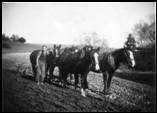
Waitepeka
Ploughing at Waitepeka |
District about six miles from Balclutha |
‘Wai’ means stream, ‘peka’ branch |
|
Waitepeka Stream |
Originally flowed from Waitepeka in easterly direction below Finegand and around eastern side of Otanomomo swamp, into the Puerua River |
River course has been altered, part of stream joining Clutha River below Finegand, the other flowing through Paretai into Puerua River |
|
Waiwera/Waiwera South
|
District and old railway station 24km W of Balclutha |
Named after river rising in Steep Face district, passing to W of Brown Dome and E of Waiwera Cone, then NW to Clutha River. |
|
Wallace Head |
Headland on south coast about 2 miles E of Longbeach creek |
|
|
Wangaloa |
District up coast from Coal Point |
|
|
Warepa |
District and old railway station 13km W of Balclutha. |
One of earliest settlements was at Warepa Bush. |
|
Washpool Creek |
Flows easterly from Kaitangata hills, enters sea above Coal Point |
Maori name was ‘Te Waihoaka’, the grindstone stream, after stone used to work greenstone and other hard stone for tool and weapon making |
|
Washpool Stream |
Stream flowing through Wharetoa district into Pomahaka River |
|
|
Wattys Stream |
Small stream flowing through Clifton into Waiwera about 3 miles from Clutha River |
Also a Wattie’s Creek at Conical Hills |
|
Wetherstones |
3km from Lawrence |
Named after WETHERSTONE brothers who found gold while pig hunting |
|
Wharetoa |
District on west of Clutha River about 3.5 miles SW of Tuapeka Mouth |
|
|
Wharuarimu |
Name of post office opened 1908, school called ‘Rimu’ |
|
|
Whawhapo Creek |
Small creek between Kaka Point and Karoro |
Name means ‘crawling by night’ in reference to incident in Maori fighting |
|
White Head |
Headland 3 miles SW of Owaka Harbour |
|
|
Willsher Bay |
Bay at mouth of Karoro stream, near Kaka Point |
George Willsher and companions settled here in 1840 |
|
Wisp Hill |
Most prominent peak in Wisp Range, the watershed between Catlins River and headwaters of Owaka River |
Wisp Hill gave name to Brugh’s Run “The Wisp’ and was given by wife of John CLARKE in 1873. There is a Wisp Hill in Dumfriesshire. |
|
Woolshed, The |
Early name for Glenore district |
Named such because of large woolshed erected in late 1850’s by James SMITH |
A – B C – E F – I J – M N – Q R – T U – Z
|
Sources: |
‘Pioneering in South Otago’ by F Waite, pub. 1948 ‘Catlins Pioneering’ by AR Tyrell, pub. 1989 ‘Faith and Toil’ by DJ Sumpter and JJ Lewis, pub 1949 ‘Full Circle’ 1975 ‘Place Names of New Zealand’ by AW Reed, pub 1975 ‘Otago Place Names’ by JH Beattie, pub |
Please let us know of any we have missed, or are incorrect
Contact: Webmissus at help.desk@balcluthagenealogy.org.nz
‘Locations U – Z’ last updated 6 July 2012
© Balclutha Branch NZSG (Balclutha Genealogical Society)