LOCATIONS
C – E
A – B C – E F – I J – M N – Q R – T U - Z
|
PLACENAME |
WHERE |
HISTORY |
|
Caberfeidh |
Mountain in Catlins district, and old railway station on Catlins river line. About 2mls nth of Maclennan. |
Named by John MacKENZIE, was motto of Seaforth Highlanders |
|
Campbell’s Point / Campbell’s Bay |
Point on sea coast 2ml nth of Tokata Point, near Kaka Point |
Named after early resident in area |
|
Canada Reef |
Name of quartz mine in Table Hill area. Canada Bush up north branch of Tokomairiro River |
Name taken from early name for district |
|
Cannibal Bay |
Small bay north of False Island about 8km from Owaka |
Maori name ‘Oraki-utuhia’. Many unreliable stories as to origin of name. Old Maori ovens in vicinity |
|
Carol |
Tussock hills of Kaihiku Range in Waiwera district |
Named after home, near Dunrobin Castle, Scotland, of father of John ANDERSON (1st white child born site of Dunedin, 1846) |
|
Carterhope |
Old estate on main highway near Warepa |
Purchased by James BORTHWICK in 1861 |
|
Cathedral Caves |
Series of large caves named by Dr Hocken 1892 |
|
|
Catlin’s Cone |
Mountain 2290ft high about 16mls nth of Long Beach |
Otago-Southland boundary |
|
Catlin’s Lake |
Tidal flat which Catlins River flows into |
Maori name ‘Pounawea’ |
|
Catlin’s River |
Rises nth of Catlin’s Cone, flows past south slopes of Wisp Range, past Ratanui to Catlin’s Lake. |
Between 1863 and 1870, Catlin’s River referred to district known as ‘The Landing’ Maori name ‘Kuramea’ |
|
Catlins |
Name given in general to Owaka district |
Edward CATLIN, master of a trading schooner, bought large tract of land from Tuhawaiki |
|
Cedar Hill |
South of Chloris Stream between Catlins and Owaka Rivers |
|
|
Cemetery Hill |
Small hill 1ml sw of Port Molyneux where cemetery situated |
Maori name ‘Puke-ti’ cabbage tree hill |
|
Chasland’s Mistake |
Headland 4ml sw of Tautuku Peninsula |
Allegedly, CHASLAND once mistook this long headland for Cape Saunders. Thought more likely that Chasland himself named it that after having arrived there late one evening, discovering herd of seals and made the mistake of leaving them till morning, when it was found the seals had left in the night. Maori name ‘Maki-ti’ branch of cabbage tree |
|
Chasland’s River |
Known as Waipati River |
Wai - river, pati - shallow |
|
Chaslands |
District between Tautuku and Waikawa |
Named after Thomas CHASLANDS, of whaling fame |
|
Chinaman Flat |
Near Tuapeka |
Named such in reference to large numbers of Chinese on goldfields |
|
Chloris Stream |
Rises SE of Wisp Hill, flows into Catlins River |
|
|
Chrystals Beach |
On the coast near Milton |
Named after Francis CHRYSTALL, early settler and proprietor of boarding house |
|
Circle Hill |
District NW of Milton deriving name from a circular topped hill |
|
|
Clarendon |
10km north from Milton |
Named by J H HARRIS, superintendent of Otago after his ancestor, Earl of Clarendon in reign of Charles II |
|
Clarksville |
District at junction of Main South and Central Highways, 3km from Milton. Early spelling ‘Clarkesville’ |
Named after Henry and Jasper CLARK who were early settlers in area |
|
Clifton |
District, former Estate near Waiwera |
Acquired by William TELFORD |
|
Clinton |
Town 31km SW of Balclutha |
Family name of Duke of Newscastle, Secretary for Colonies 1852-54. At one time the name Clinton was desired for Invercargill, unsuccessfully, and the name ‘wandered around looking for a home’ for a time. In 1873 Popotunoa became Clinton |
|
Clutha River |
Major river with headwaters in Central Otago. Balclutha is situated on the lower river. |
Clutha is Gaelic for Clyde. Maori name from source in Lake Wanaka to the sea was ‘Mata-au’ meaning surface current. |
|
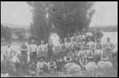
Clydevale
Shearing Gang at Clydevale 1894 |
Area between fork of Clutha and Pomahaka Rivers about 29km from Balclutha. |
Name refers to the River Clyde. Name given by NZ & Australian Land Company in 1863, name of estate. |
|
|
|
|
|
Coal Point |
On the coast east of Kaitangata |
Named by Tuckett |
|
Conical Hills |
NW of Waipahi |
Named after cone shaped hill |
|
Conical, The |
Small conical hill on west bank of Waiwera River |
|
|
Coronet Hill |
SW of Kuriwao Peak |
|
|
Cosgrove Island |
Small island 2ml NW of Long Point |
Maori name ‘Puke-mau-kuku |
|
Crichton |
8km south from Milton |
Named after early settler |
|
Crookburn |
Stream rising near Waitahuna West, flowing into Clutha River downstream from Tuapeka Mouth |
|
|
Dalhousie |
Name for Tuapeka Mouth c1860 |
|
|
Dull Burn |
Otherwise known as Black Burn |
|
|
Dunkeld |
Alternative name for Beaumont (still used on land maps in 1975) |
This Perthshire name given by surveyor CW ADAMS |
|
Dutton’s Bridge, Dutton’s Hill |
Bridge over Owaka River 2km north of Owaka |
|
|
Earlstoke |
Near Willsher Bay |
|
|
Elbow, The |
Deep corner on Owaka River at Pounawea |
|
|
Evans Flat |
5km from Lawrence |
Named after goldrush hotel proprietor, David EVANS |
A – B C – E F – I J – M N – Q R – T U - Z
|
Sources: |
‘Pioneering in South Otago’ by F Waite, pub. 1948 ‘Catlins Pioneering’ by AR Tyrell, pub. 1989 ‘Faith and Toil’ by DJ Sumpter and JJ Lewis, pub 1949 ‘Full Circle’ 1975 ‘Place Names of New Zealand’ by AW Reed, pub 1975 ‘Otago Place Names’ by JH Beattie, pub |
Please let us know of any we have missed, or are incorrect
Contact: Webmissus at help.desk@balcluthagenealogy.org.nz
‘Locations C - E’ last updated 6 July 2012
© Balclutha Genealogical Society (Balclutha Branch NZSG)