LOCATIONS
A – B
A – B C – E F – I J – M N – Q R – T U - Z
|
PLACENAME |
WHERE |
HISTORY |
|
Adam’s Flat |
Small flat 14km south of Milton |
Named after landowner, James ADAM. Became prominent when gold discovered |
|
Ahuriri/Ahuriri Flat |
Rural district between Glenomaru and Otekura; the valley through which the Karoro stream flows. |
Named after Ngaitahu chief, Tauhuriri |
|
Ajax Hill |
2290ft high, situated at headwaters of Maclennan River. |
|
|
Akatore |
District 21km E of Milton |
‘Aka’ harbour, ‘torea’ several kind of wading bird |
|
Albert Downs |
Early estate in Kaihiku district |
|
|
Alberts Cap |
Small hill near old railway line between Kaihiku and Waiwera |
Name first appears on Kettle’s map of 1847 as ‘Albert’s Hat. Reference to Prince Albert (Queen Victoria’s husband) |
|
Anise Hill |
South side of Pomahaka River opposite to where Rankleburn flows from the north. |
Names after native aniseed plant. |
|
Arthurton |
Railway station near Otago-Southland boundary |
Named after a Mr ARTHUR, traffic manager c1878 |
|
Ashley Downs |
Name from an estate near Waiwera, 10km from Clinton |
Named by James GIBSON, early landowner in honour of orphanage operated by Dr George MULLER and/or home of James MULLER of Bristol |
|
Awakia Stream |
Between Waiwera Cone and Kuriwao Peak |
Also known as Marshall’s Creek after Matthew MARSHALL who had hut there c1865 |
|
Awa-ki-aia/Awa-Kaeaea |
Old Maori name for Kuriwao Stream |
Maori meaning ‘Sparrow-hawk Stream’ |
|
Awakiki Bush |
Early settlement near Puerua |
Sometimes referred to as Awariri |
|
Awamangu |
District 16km up river from Balclutha, situated on small creek called Black Burn (or Dull Burn) |
‘Awa’ valley or stream ‘Mangu’ is black |
|
Awatea |
3 miles east of Purekireki, 23km from Owaka, head of Puerua Valley |
‘Tea’ white or clear ‘Awa’ river, or ‘broad daylight, middle of the day’ |
|
Back Stream |
Tributary of Pomahaka River |
|
|
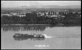
Balclutha
SS Clyde passing Balclutha c1910 |
Town at centre of Clutha district, 85km from Dunedin Also known as ‘Iwikatea’, ‘Clutha Ferry’ and ‘McNeill’s Ferry’ (Post Office name changed to Balclutha in 1865) |
Name is gaelic for the Clyde, Bal is town
|
|
Balloon |
Balloon loop in the Matau branch of Clutha River near Kaitangata |
Was site of Ngaitahu pa known as ‘Katore-e-kinau’ |
|
Barratta Creek |
Small tributary creek emptying into Puerua River at Port Molyneux |
Presumed correct spelling ‘Brada’, perhaps a Welsh name (most names of streets in old Port Molyneux township were Welsh |
|
Beaumont |
District and settlement 53km from Milton on Clarkesville-Alexandra Highway Also Beaumont River. Early alternative name, given by surveyor CW ADAMS of Dunkeld |
Named after Bowmont Burn, Scottish border name, probably given by THOMSON and GARVIE in 1857. |
|
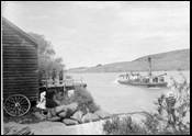
Begg’s Beach
|
Beach on north side of Clutha River c14km upstream from Balclutha |
Begg’s Beach, Clutha River |
|
Bellamys |
Near Lovells Flat. |
Originally Bellenys, this name was given by Edmund BOWLER after his sister’s estate in Ireland |
|
Benhar |
Village about two miles north of Stirling. |
Site of old McSkimming’s Pottery Works. Named after village near Airdrie in Scotland. |
|
Big Mill |
Hina Hina, Catlins. |
Started by Guthrie and Larnach in 1871, the Big Mill was situated near the site of the present Yacht Club |
|
Bishops |
11km from Balclutha, was a post office between Stony Creek and Hillend (sometimes called Hillend or Lower Hillend) |
Named after early settler in district |
|
Black Cleugh |
Creek flowing out of Blue Mountains easterly into Clutha River. |
Maori name was ‘Kowai’ |
|
Blowhole, The |
South of Jack’s Bay |
|
|
Blue Mountains |
Dividing range between the Clutha and Pomahaka Rivers. First appears on maps as Mount Valpy |
|
|
Blue Spur |
5km from Lawrence |
|
|
Bonnet, The |
Also known as ‘Scotman’s Bonnet’. About 2 miles down the Owaka River from Tahatika |
Prominent rock with trees on it resembling a Scotman’s bonnet. |
|
Bowlers Creek |
8km from Tuapeka |
Named after miner, of DAVEY and BOWLER, first owner of Bellamys station |
|
Brown Dome |
Mountain at head of Owaka Valley , behind Kaihiku Range |
Head of Waiwera River |
|
Bull Creek |
District and strip of coast 11 miles E of Milton |
One version say named derives from activities of wild bull in early days, other as named after Robert O’NEILL an ex-whaler of great strength aka John BULL. Maori name ‘Moanariri’ |
|
Burning Plains |
Seam of lignite coal in Pomahaka district which has been burning since Maori times |
‘Te Ahiaue’ is Maori name – ‘aue’ is fire |
|
Burnt Flat |
Catlins |
|
A – B C – E F – I J – M N – Q R – T U - Z
|
Sources: |
‘Pioneering in South Otago’ by F Waite, pub. 1948 ‘Catlins Pioneering’ by AR Tyrell, pub. 1989 ‘Faith and Toil’ by DJ Sumpter and JJ Lewis, pub 1949 ‘Full Circle’ 1975 ‘Place Names of New Zealand’ by AW Reed, pub 1975 ‘Otago Place Names’ by JH Beattie, pub |
Please let us know of any we have missed, or are incorrect
Contact: Webmissus at help.desk@balcluthagenealogy.org.nz
‘Locations A – B’ last updated 6 July 2012
© Balclutha Genealogical Society (Balclutha Branch NZSG)